Other States
Explained | Why was the Miya Museum in Assam sealed?


The story so far: Disaster struck Dima Hasao, central Assam’s hill district, in mid-May after incessant heavy rainfall. The 170 km railway line connecting Lumding in the Brahmaputra Valley’s Hojai district and Badarpur in the Barak Valley’s Karimganj district was severely affected. The Assam government and Railway Ministry’s assessments said the district suffered a loss of more than ₹1,000 crore, but ecologists say the damage could be irreversibly higher.
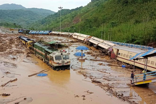
Assam is used to floods, sometimes even four times a year, resultant landslides and erosion. But the pre-monsoon showers this year have been particularly severe on Dima Hasao, one of three hill districts in the State. Landslips have claimed four lives and damaged roads. The impact has been most severe on the arterial railway, which was breached at 58 locations leaving the track hanging in several places. The New Haflong station catering to district headquarters Haflong bore the brunt of nature’s fury when a passenger train, whose passengers were evacuated in time, was almost buried in mud. The disruption of train services, unlikely to be restored soon, has cut off the flood-hit Barak Valley, parts of Manipur, Mizoram and Tripura.
Dima Hasao straddles the Barail, a tertiary mountain range between the Brahmaputra and Barak River basins. The district is on the Dauki fault (the prone-to-earthquakes geological fractures between two blocks of rocks) straddling Bangladesh and parts of the northeast. British engineers were said to have factored in the fragility of the hills to build the railway line over 16 years by 1899. The end result was an engineering marvel 221 km long over several bridges and through 37 tunnels, laid along the safer sections of the hills. A project to convert the metre gauge track to broad gauge was undertaken in 1996 but the work was completed only by March 2015 because of geotechnical constraints and extremist groups. The broad-gauge track was realigned to be straighter, but a 2009-10 audit report revealed that the project had been undertaken without proper planning and visualisation of the soil strata behaviour.
Citing an engineering and geology expert, the report gave the example of the disaster-prone Tunnel 10 on the realigned track that was pegged 8 meters below the bed of a nearby stream. Retired railway officials admitted that faulty experiments and the “greed” of a few not only made the track vulnerable to the forces of nature but also escalated the cost of the project from ₹1,677 crore to ₹5,500 crore. The Commissioner of Railway Safety had in July 2015 observed that the track was unsafe for passengers after nine derailments and the sinking of the track in 14 sections four months after the route was opened for goods trains.
There is a general consensus that other factors have contributed to the situation Dima Hasao is in today. Roads in the district, specifically the four-lane Saurashtra-Silchar (largest Barak Valley town) East-West Corridor, have been realigned or deviated from the old ones that were planned around rivers and largely weathered the conditions. Locals said the arterial roads build over the past 20 years often cave in and get washed away by floods or blocked by landslides. Shortened cycles of jhum or shifting cultivation on the hill slopes and unregulated mining have accentuated the “man-made disaster”, as former MLA from the district Samarjit Haflongbar wrote in a letter to Assam Chief Minister Himanta Biswa Sarma. “…massive extraction of river stone, illegal mining of coal and smuggling of forest timber… has led to the disaster. These activities have increased water current besides weakening either side of riverbanks such as Jatinga, Mahur, Langting and other rivers along with other streams and tributaries,” he wrote, holding the chief of the autonomous district council responsible.
Meghalaya aside, Dima Hasao is the geographical link to a vast region comprising southern Assam’s Barak Valley, parts of Manipur, Mizoram and Tripura. This region has an alternative, less disaster-prone highway through Meghalaya linking the country beyond and may not thus be impacted by any damage to the four-lane highway through Dima Hasao, once it is completed. But the Lumding-Badarpur railway line has been the lifeline for this region since goods trains started operating in March 2015.
Moreover, this track is vital for India’s Look East policy that envisages shipping goods to and from Bangladesh’s Chittagong port via Tripura’s border points at Akhaura and Sabroom, the last railway station near the Feni River that serves as the India-Bangladesh border. The Dima Hasao line also links the ambitious 111 km Jiribam-Imphal railway project in Manipur being built on similar, landslide-prone terrain. There are plans to extend the Jiribam-Imphal line, which will have India’s tallest railway bridge and the longest railway tunnel, to Myanmar and beyond. Such plans seem distant with Tripura and Mizoram indicating they cannot always rely on the rail connectivity through Dima Hasao. The two States have approached the Ministry of External Affairs for bringing fuels and essentials through Bangladesh, preferably on a long-term basis.