Environment
Who should pay for climate damage?


The story so far: The India Meteorological Department (IMD) has said that the monsoon has begun to retreat from Rajasthan.
The monsoon is a sea-breeze that has consistently landed in the Indian sub-continent for thousands of years. It enters mainland India between the last week of May and the first week of June — though June 1 is its official onset date over Kerala. The IMD only counts the rainfall between June 1 and September 30 as monsoon rainfall. This doesn’t mean that the monsoon system ceases to pour rain over India from October 1. In fact, monsoon-related rain can continue well into the first fortnight of October and only really retreats from India by late October. It is then replaced by the retreating, or northeast monsoon in November which is the key source of rainfall for several parts of Tamil Nadu, Andhra Pradesh and north interior Karnataka.
The monsoon begins its withdrawal from the last State it reaches, which is Rajasthan. Around September 15, cyclonic systems from the Arabian Sea and the Bay of Bengal that fuel the monsoon from June-September are replaced by an ‘anti-cyclone’ circulation which means dry, windless conditions start to prevail over western and northern India. More technically, withdrawal is a cessation of rainfall activity over northwest India for five straight days, an anticyclone establishing itself in the lower troposphere and a marked reduction in moisture content. A day after the IMD announced the withdrawal, torrential rains began in several parts of north India.
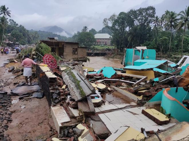
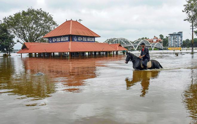
Monsoon rainfall in India has been surplus by around 7% this year though with extreme inequity. Central and southern India saw a sharp surge in rainfall. Rains in Central India were surplus by 20% and in southern India by 25%, with the last month seeing several instances of flooding in Kerala, Karnataka and Madhya Pradesh. On the other hand, large parts of U. P., Bihar, Odisha have seen large deficits. The east and northeast of India have reported a 17% shortfall and the northwest 2%. This has impacted sowing of the kharif, or summer crop. Paddy planting has been impacted with sown area 5.51% lower than last year, according to the Agriculture Ministry. The Centre is expecting a minimum of six-million tonne shortfall in rice production and this is likely to elevate inflation.
In April, the IMD had forecast ‘normal’ rains over India but by May-end indicated it to be above normal. Central India and the southern peninsula were expected to get 6% more than their historical average but what we have seen are rains far in excess of this. These heavy rains are premised on a La Nina, the converse phenomenon of the El Nino and characterised by cooler than normal sea surface temperatures in the central Pacific.
While, El Ninos are linked to reduced rains over India, La Ninas indicate surplus rainfall. India is seeing an extended spell of the La Nina, called a ‘triple dip’ La Nina which is a phenomenon lasting across three winter seasons in the northern hemisphere. This is only the third time since 1950 that a triple dip La Nina has been observed. This, in part, is why for the third year in a row, India is seeing surplus rain in September, a month that usually marks the retreat of the monsoon.
Since 2019, monsoon in India has returned surpluses, barring a slight dip last year. The June-September rainfall in 2019 was 10% more than the 88 cm that India usually gets. Though June saw deficit rain, the months of July and August returned extra rain, with September registering 52% more rain than normal. In 2020, India saw 9% more rain with August registering 27% more rain and September 4% more than its usual quota. The rainfall over the country as a whole, in 2021, was 1% less than normal though rainfall in September was a remarkable 35% above what is usual. This year the monsoon is already in surplus by about 6% and a vigorous September is likely to see India post yet another year of surplus rain. Three years of above normal rain in a block of four years is unprecedented in more than a century of IMD’s record keeping, data suggests.